North Hunt and Fish Club
  • Fishing
  • Tips
  • Hunting
  • News
  • Gear
  • Blog
No Result
View All Result
North Hunt and Fish Club
  • Fishing
  • Tips
  • Hunting
  • News
  • Gear
  • Blog
No Result
View All Result
North Hunt and Fish Club
No Result
View All Result

Rogers Satellite Now Supports CalTopo, AllTrails & onX

Home News

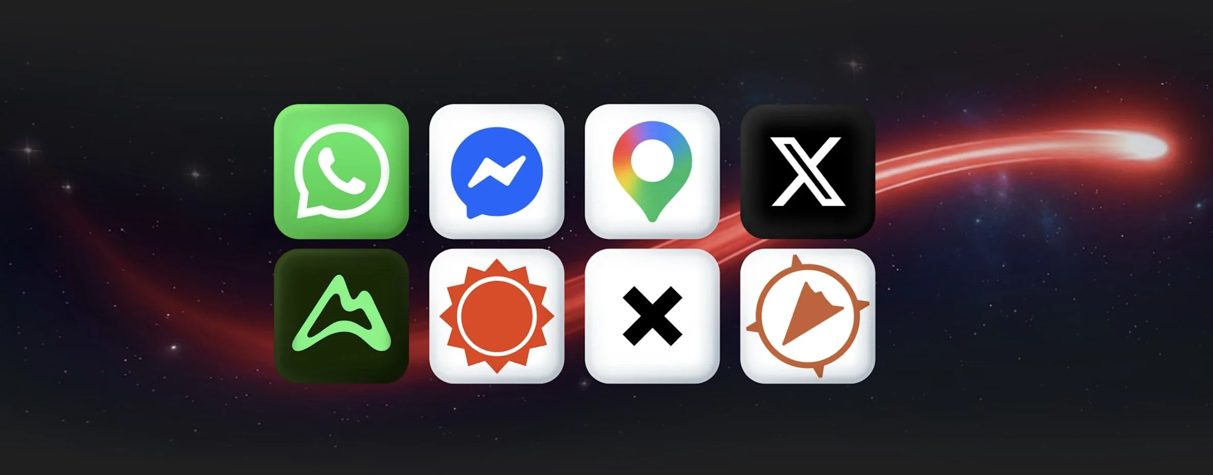
Rogers launched their satellite service for mobile phones mid-2025 and are still adding to the service now that it has left beta status. In addition to text messaging, Rogers Satellite now supports some of the most popular apps to keep you connected in areas without cellular coverage. Compatible apps have been updated by developers to work over satellite and may perform differently than on cellular network. Rogers mentions that more apps are to come, but currently they list…

  • CalTopo

  • AllTrails

  • onX

“Canadians should be able to stay connected no matter where their travels take them. With Rogers Satellite now powering these apps, customers can stay on top of weather, find their way on remote highways and trails, and check in with family when they’re beyond the reach of traditional cell towers.”

— Mark Kennedy, Chief Technology Officer, Rogers

On top of these new apps, Rogers Satellite already supports video and voice calling through WhatsApp, Google Maps, AccuWeather, X, as well as text-to-911.

Top destinations for Rogers Satellite include Lacs-du-Témiscamingue, Quebec; the Garibaldi/Sea-to-Sky Region, British Columbia; Canmore, Alberta; and Algonquin Provincial Park, Ontario.

If you’re interested in trying Rogers Satellite, you can currently get it for $10 for 12 months by adding it to your existing Rogers cell phone plan or $0/mo for up to 24 months on select plans.

Tags: GPSTechnology
Previous Post

‘They’re everywhere’: Growing population of beavers affecting traditional lands in Arctic – CBC

Next Post

CalTopo Updates Satellite Imagery Using Vantor

Related Posts

CalTopo Updates Satellite Imagery Using Vantor
News

CalTopo Updates Satellite Imagery Using Vantor

May 6, 2026
News

‘They’re everywhere’: Growing population of beavers affecting traditional lands in Arctic – CBC

May 5, 2026
How To Use Your ‘Maps By Jeff’ On ArcGIS Earth
News

How To Use Your ‘Maps By Jeff’ On ArcGIS Earth

May 2, 2026
New CCM Exhibit Opening May 14th: Canoe Perspectives
News

New CCM Exhibit Opening May 14th: Canoe Perspectives

May 4, 2026
Trans Canada Trail State Of The Trail Sector Research Study
News

Trans Canada Trail State Of The Trail Sector Research Study

May 5, 2026
News

Garden-hunting boy brings his mother a live present – Yahoo News Canada

April 29, 2026
Next Post
CalTopo Updates Satellite Imagery Using Vantor

CalTopo Updates Satellite Imagery Using Vantor

Leave a Reply Cancel reply

Your email address will not be published. Required fields are marked *

  • Trending
  • Comments
  • Latest
Best Walleye Recipes: 7 Delicious Ways to Cook Fresh Walleye Fish

Best Walleye Recipes: 7 Delicious Ways to Cook Fresh Walleye Fish

March 19, 2026
2026 Manitoba Hunting Regulations: Essential Updates and What’s Changed

2026 Manitoba Hunting Regulations: Essential Updates and What’s Changed

March 3, 2026
2026 Ontario Hunting Regulations: Essential Updates and What’s Changed

2026 Ontario Hunting Regulations: Essential Updates and What’s Changed

February 16, 2026
Moose Hunting Season in Ontario: What You Need to Know?

Moose Hunting Season in Ontario: What You Need to Know?

November 18, 2025
BC Hunting Synopsis 2026 – What Every Hunter Needs to Know

BC Hunting Synopsis 2026 – What Every Hunter Needs to Know

March 13, 2026
Complete Guide to Ontario Fishing Regulations 2026: What Every Angler Needs to Know

Complete Guide to Ontario Fishing Regulations 2026: What Every Angler Needs to Know

February 9, 2026
Rogers Satellite Now Supports CalTopo, AllTrails & onX

Rogers Satellite Now Supports CalTopo, AllTrails & onX

0

$50K fine, 10-year ban issued after B.C. man illegally hunts wildlife – CBC

0
CalTopo Updates Satellite Imagery Using Vantor

CalTopo Updates Satellite Imagery Using Vantor

0

Once-controversial black bear hunt faces changes in Ontario – CBC

0
Trans Canada Trail State Of The Trail Sector Research Study

Trans Canada Trail State Of The Trail Sector Research Study

0

‘They’re everywhere’: Growing population of beavers affecting traditional lands in Arctic – CBC

0
CalTopo Updates Satellite Imagery Using Vantor

CalTopo Updates Satellite Imagery Using Vantor

May 6, 2026
Rogers Satellite Now Supports CalTopo, AllTrails & onX

Rogers Satellite Now Supports CalTopo, AllTrails & onX

May 7, 2026

‘They’re everywhere’: Growing population of beavers affecting traditional lands in Arctic – CBC

May 5, 2026
How To Use Your ‘Maps By Jeff’ On ArcGIS Earth

How To Use Your ‘Maps By Jeff’ On ArcGIS Earth

May 2, 2026
New CCM Exhibit Opening May 14th: Canoe Perspectives

New CCM Exhibit Opening May 14th: Canoe Perspectives

May 4, 2026
Trans Canada Trail State Of The Trail Sector Research Study

Trans Canada Trail State Of The Trail Sector Research Study

May 5, 2026
North Hunt and Fish Club

Copyright © 2024 North Hunt Fish Club .
North Hunt Fish Club is not responsible for the content of external sites.

Navigate Site

  • Fishing
  • Tips
  • Hunting
  • News
  • Gear
  • Blog

Follow Us

Welcome Back!

Login to your account below

Forgotten Password? Sign Up

Create New Account!

Fill the forms below to register

All fields are required. Log In

Retrieve your password

Please enter your username or email address to reset your password.

Log In

Add New Playlist

No Result
View All Result
  • Fishing
  • Tips
  • Hunting
  • News
  • Gear
  • Blog

Copyright © 2024 North Hunt Fish Club .
North Hunt Fish Club is not responsible for the content of external sites.